Iran releases new map outlining areas in Hormuz under its control
Iran's Islamic Revolutionary Guard Corps (IRGC) on Monday issued a new map outlining areas in the Strait of Hormuz that it says under its control.
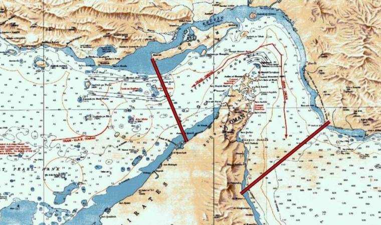

The designated zone stretches between two defined maritime lines: one running from the western tip of Iran’s Qeshm Island to Umm Al Quwain in the United Arab Emirates, and another extending from Kuh-e Mobarak in Iran to the area south of Fujairah in the UAE, the semi-official Fars news agency reported.
It was not immediately clear to what degree the claimed area of control has changed.
The US and Israel launched strikes against Iran on Feb. 28, triggering retaliation from Tehran against Israel, as well as US allies in the Gulf, along with the closure of the Strait of Hormuz.
Since April 13, the US has enforced a naval blockade targeting Iranian maritime traffic in the strategic waterway.
A two-week ceasefire was announced on April 8 through Pakistani mediation, followed by direct talks in Islamabad on April 11, but no agreement was reached on a lasting truce.
US President Donald Trump later extended the ceasefire without setting a new deadline, following a request from Pakistan.
Most Read News
-
 Azerbaijani president pardons French national convicted
-
Indonesia records 175,000 respiratory infections as
-
Trump meets with Venezuela’s acting president in 1st
-
Netanyahu won’t meet Trump during ‘brief’ UN visit
-
Board of Peace to unveil $2.45B Gaza recovery plan
-
22-year-old worker dies after fall at Rome’s Colosseum
-
Netanyahu failing after Macron criticizes occupier
-
White House defends Trump’s media ban